

For the final, I have worked on the details of how buildings will relate with each other and with the canal that I use to take water inside. Canal and the inner wetland that created by it shape the public areas and interaction between user types. Also, two different types of circulation were defined separately for machine system users and general public users.
Category: ARCH401


Second Prejury – System Design
For the next step of the project, I focused on a system design to filtrate the water before taking it inside to the wetland through my canals that has come from aqueduct idea. Filtration cleans the water from every toxic material caused by the industry along the path of the stream. Filtration have 3 phases as physical, chemical & vegetative and program components works with these 3 steps. Aim is healing the ecosystem.


First Prejury – System Design

After the program proposal jury, we have continued to the project individually and everybody has started to work on system design which should answer the questions of WHY (context), WHAT (concern), HOW (system). We further the words we have used at ECO_lexicon and designed the system according to these terms. I have focused on hydro-autistic situation caused by the artificial invasion. I proposed a system which could be able to break this invasion and regain the permeability within the wetland. I searched and revised the historical aqueduct system to achieve my proposal and located the program components according to it. To create the system we have been asked to study with serial sections.


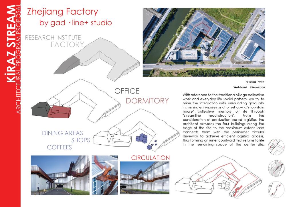
Architectural Program Proposal – Kiraz Stream


ECO_lexicon_revision


Mapping the Context – Kiraz Stream


GEO-ZONE map shows the zoning which occurred by natural features of land and artificial interventions in manner of land-use and borders. Artificial land-use includes industrial, residential, commercial, military and landfill areas and naturally zoned areas are wetlands and swamps which also include bird habitat in boundary of protected area. Beside that, artificial borders include car roads and rail roads which are the most visible elements of zoning that create sudden transition between coast side and inner side of the site. These zones show how artificial usages distributed in an expanded area while squeezing the natural usages at the coast side.
INSTABILITY OF LAND map contains the analysis of the three maps: Geo-Zone, Wetland, Eco-Accessibility and shows the instability of land in sections. It shows the active and passive relations between the layers (earth, water, artificial) that cause constancy and inconstancy. To see clearly the information of the blocking elements from eco-accessibility map and zoning from geo-zone map, artificial elements are exaggerated like roads, buildings and concrete surfaces. Beside that passive relation of earth and artificial is showed with more defined lines to explain stability. Moreover, active relation between earth and water is showed with indefinite lines to explain their integration to each other. Active relation between them means that it is not stable and changeable during sections and time.
After collecting many analysis in one, we decided to apply some operations to the sections. To emphasize the artificial and inaccessibility it create we uplifted them. Than to show the active relation of water and earth we pixelated the water, diffused and dissolve it through the earth. And to support these operations we bored and carved the earth and made tunnels to dissolve the water in it.
Site Analysis – Waterfront


ECO_lexicon_how?


1 Term 1 Case


