Final Jury – PHOENIX

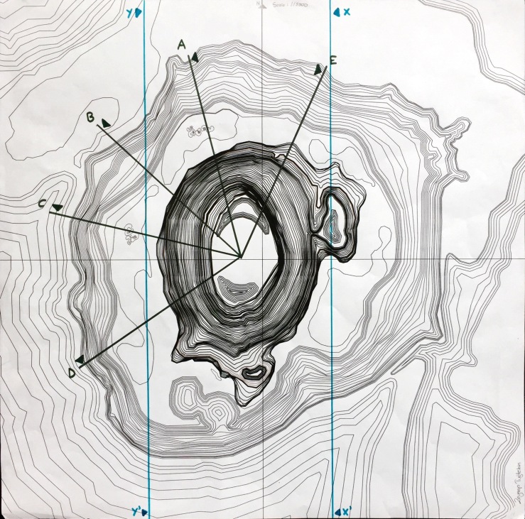
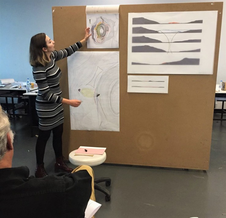
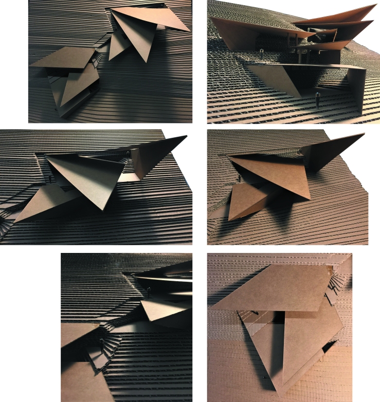
For the final jury, we presented our 1/100 final models of the structures that we have produced for Meke Maar and took reference from prejury analysis and initial model ideas. My first strategy was using visual connections to have an idea about to the whole site. For the final, I improved this strategy.

IMG_1752

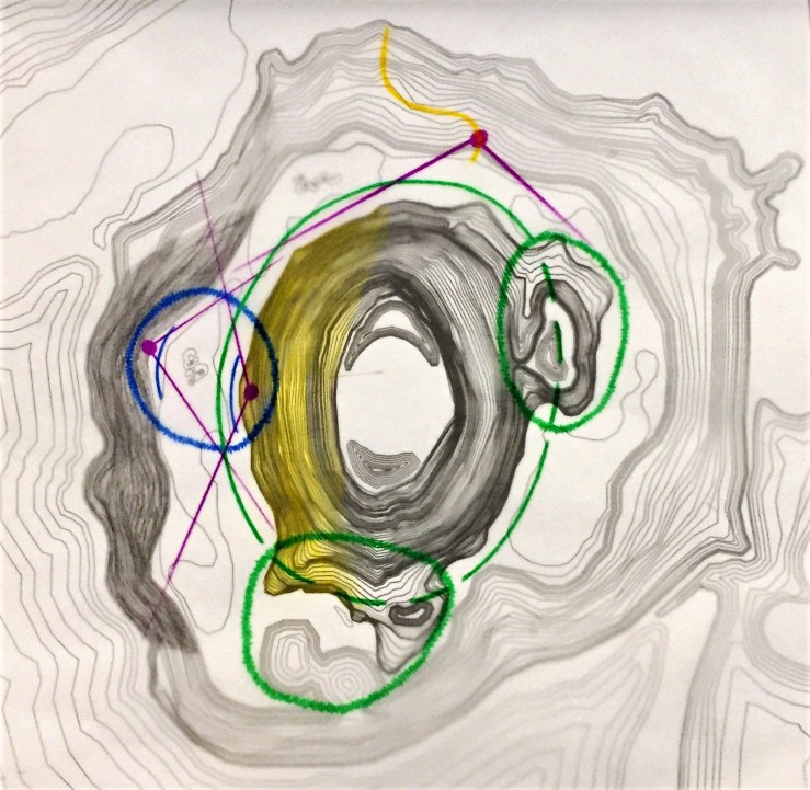
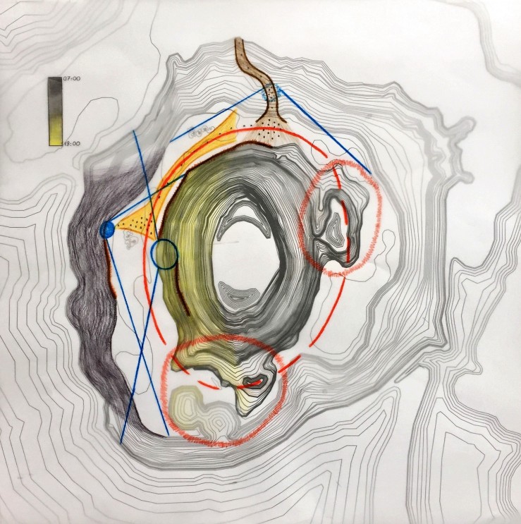
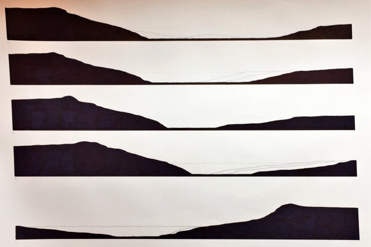
The blue circle is the place that I have chosen to work because it is the point that where mountain’s turning direction changes. At that point, mountain provides some experiences to increase visuality. After people walked through that part, they start to see new things such as the small hills at the South because mountain could not hide them anymore because of its circularity. Also, the height of the mountain can be used to climb to increase visual connections with the behind of the cliffs and the small hills. Therefore, while producing my structure I tried to reflect the mountain’s turning and rising shape. In this way, I could achieve my strategy.

IMG_1753

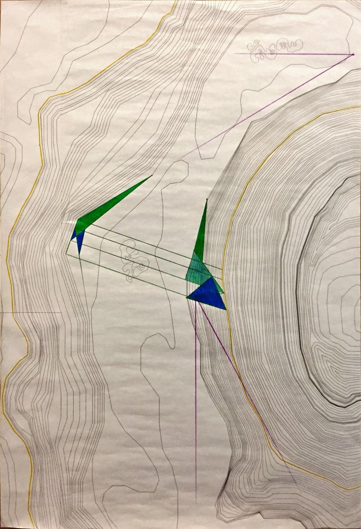
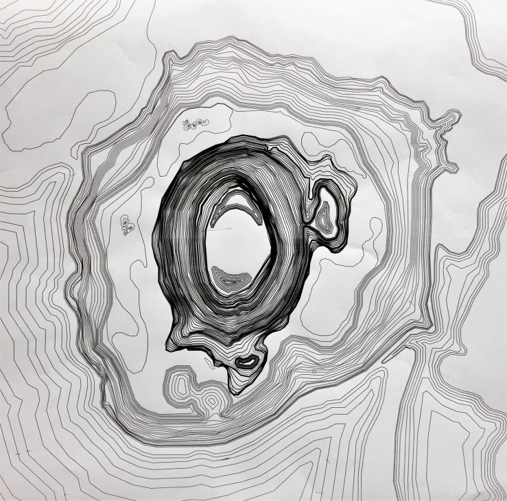
While deciding the abstract shape of my cliff and mountain structures I took references from the topography. I tried to make the structures general positions direct people through that place. Also, they are in harmony to create an inbetween area and to make people want to experience them both. In this way, they can experience many things that I have mentioned in my prejury post. I decided to focus on the mountain structure to make its model. I used triangular shapes because I realized that with the help of the sharp points of the triangles I can show the mountain’s turning movement strongly. Because points point out and direct something.

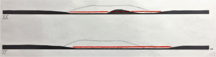
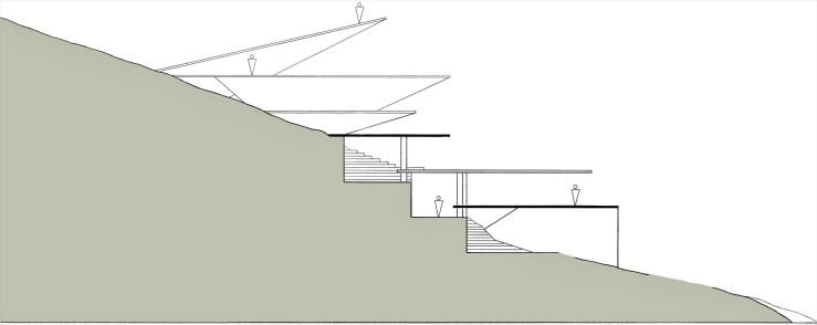
I think that I should make two parts: climbing and standing. Climbing part is to ease the climbing without getting tired and standing part is to rest and watch the landscape. At my first trial model, I used some pieces to define my parts and levels abstractly. Then I decided the place of the stairs and carved the mountain to give depth and dimensions. I also try to use sunlight to define circulation in the structure with the stairs and to create interesting shade and shadow conditions.

Stairs are main elements of my design. While making my final topography model I cut the stairs from the topography lines. They direct the people from entrance to the top and creates spaces around themselves. Also, at climbing part stairs follow continuous, zig zag circulation. Then at the standing part stairs follow a discontinuous route and provide spaces to rest.

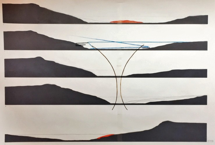
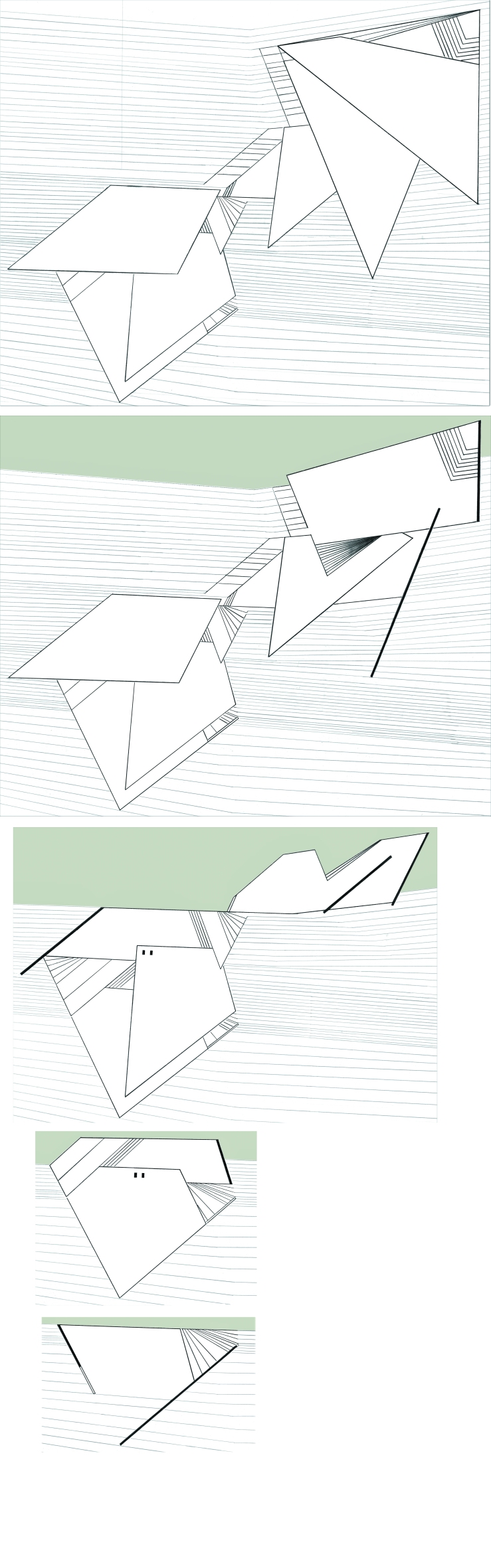
After the stairs, my main design concern was shadows. I positioned the layers by thinking the sunlight directions throughout the day. I also tried to put the stairs in direct sunlight because I think that, in my strategy, the aim of climbing is increasing the visuality with the surrounding so main elements of the climbing should be in brightness to symbolize that.

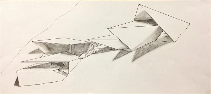
The diagram shows the relation between the stairs & the light and the route that stairs create. The sketch is a view from the ending stairs which are at the top layer and sees other layers and interesting shadows.

I took some photographs to compare the shadows in morning and afternoon times:

zeyneptugtekin_model

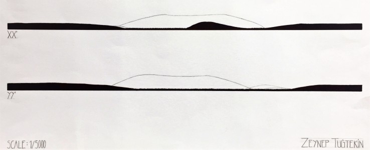
Then I drew many 1/100 plan and section drawings:

IMG_1751planlarsection

Then finally, jury day had come and sleepless nights over for this semester.


Prejury

For the prejury, we presented our individual analysis of the Meke Maar and showed our initial ideas of the spaces that we will produce.

1/5000 plan analysis

The site has a dominant circularity. However, two parts, which include small hills and islands, break this circularity and create discontinuities. Between them, there is a long, empty, continuous part so I think that I should study on that emptiness which has many potentials to experience different things on the site. I want to make my people experience many things, have a general idea of the whole site without walking all around it and discover all surprises that the site present so I used visual connections and positioned my spaces according to that. First, when entering the site from the natural path it is possible to see the small hill. Then, on the lake, the path that I have made will direct the people towards the west side. Through this path, walking on the salt ground can be experienced and the path makes it possible to walk on the soft parts of the ground which are not walkable. My path ends in the widest part of the long, empty side. I chose the widest part because I want to make people experience being so close and so far to the mountain. In this way, the whole mountain can be seen when people are near the cliffs. Also, when people are near the mountain, they can experience the texture and being on top by climbing. I made a way on the mountain to make it easy to climb and I put my spaces at the end of the way so they become at the same height with the cliffs and the small hill which is at the South. Therefore, behind the cliffs and behind the hill (islands) can be seen. Also, people can dominate the west side totally when they are at top of the space. Moreover, most of the day, West side of the mountain is shiny when the cliffs are in shadow. So I think that I can use the shadow to create a space where people can rest after walking on the long sunny path (15-20 minutes to reach the spaces).

We also took many sections to show our analysis.

section lines
section lines

XX’ and YY’ are my 1/5000 sections.

IMG_0195
1/5000 sections
IMG_0194
1/5000 section analysis

I drew these sections to show the discontinuity on the East side and long continuity on the West side.

A, B, C, D and E are my 1/1000 sections. I drew them in D, C, B, A, E order.

IMG_0201
1/1000 sections
IMG_0200
1/1000 section analysis

I drew these sections to show the changes in the whole way that people walk. I also wanted to show that, people can see the hill at the East side (section E) and can see the islands at the South (section D) at the beginning and the end of the journey. Lastly, I showed the shape of the way that goes like wide, narrow and wide. I think that I can use this analysis while doing my path.

Finally, I worked on a 1/1000 plan to present my particular analysis, positioning and shape of my constructs.

IMG_0202
1/1000 plan analysis

I positioned my constructs at the two ends of the widest part. Then, at the cliff side construct, I tried to represent the shape of the topography and looks through the mountain. At the mountain construct, I tried to represent the circularity of the mountain and I increased its visuality at each layer as increasing visuality while climbing.

The constructs create their own common area between themselves. I leave this common area empty because it has its own circulation and it is not necessary to direct people. Also, the ground is not soft at that part so people can easily walk and do whatever they wanted to do to experience this huge area.

I think that my climbing way can have less slope than the original slope by carving the mountain as in Taşkale case. In Taşkale, there is a vertical movement which is provided by carving the steep mountain. So I think I can adapt this technique to Meke. I connected my construct with the climbing path and I think that path should be the only connection between the layers of the construct again as in Taşkale and Çatalhöyük. Because at these cases, spaces are isolated from each other and their only connection is common areas. So my climbing path can be common area of the construct. Moreover, I will make it possible to walk on the roof of the construct as in Çatalhöyük case. In this way becoming on the top can be experienced more bravely.

I also made a 1/1000 initial model of my mountain side construct and walking path.

My jury was good, I could explain many things that I wanted to mention.

IMG_0190


Site Analysis

We went Konya and traveled three different geographies for site analysis: Meke Maar, Taşkale, Çatalhöyük.

Meke Maar is a huge, tectonic area which occurred after volcanic events. It has a high hill in the middle and salty, soft ground around it which was a lake previously. And this whole area surrounded by high walls, cliffs.

Then we went to the Taşkale where has storerooms in the mountain that constructed by carving the mountain. Storerooms are top of each other so it has a vertical movement and requires to climb to reach the rooms. Also, each unit only has one opening and they do not connect each other inside the mountain. They are totally isolated and separate.

Finally, we went to the Çatalhöyük where is a very old metropolis from Neolithic times. Houses are side by side, there are no streets and entrance of the houses are from the roofs. Roofs are their common area and houses and rooms have no transition between each other except the openings at the roofs. On the contrary to the Taşkale, Çatalhöyük houses have horizontal movement. Also, there are two structures which protect the excavation areas and direct the tourists.

After the site analysis, we were assigned to make sketches and diagrams that show our spatial experiences and observations. Also, we should understand the Taşkale’s and Çatalhöyük’s spatial features and try to transfer them to the Meke Maar.

After all these analyses, we produced a 1/1000 scaled model of the site. For the next steps, we will study on this model individually and develop our strategies to make spaces according to our experiences and what we want to make people experience at the site.

IMG_0199


Sketch Problem – Plan Interpretation

For the next assignment, we worked on a given 1/200 plan of a house. We considered this drawing as a section through a building and created new spatial organizations according to our interpretations of the plan.

section ground level

We could construct the ground level depending on our organization and make some small changes in the minor elements of the initial plan. However, the overall formal organization should stay as it is.

Then we made 1/100 scale model of the spatial organization that we developed. We had to clearly present the section.

We also consider the topography. I had some spaces that under the ground level and to access that spaces I made slopes at my topography.

Kolej-IN Analysis

We went to the Kolej-IN building for our first assignment of the first semester. We had to analyze the spatial qualities of the space and produce sketches that drawn according to the observations and experiences about the building such as connecting, separating, dividing, bordering, enclosing, layering, transparency and light & shadow. We also had to consider the bodily experiences such as human scale, perspective, tempo, pace.


After analysis, we prepared a sketchbook that includes our main observations.


I mostly think about the light conditions in the building. Because the first time I entered the building, I realized that there is a giant area in the middle which is so bright because of the giant windows. Then this brightest area getting darker when it goes through the downstairs and spaces are getting enclosed. So I examined that when light access decrease, also the visual relations of the spaces decrease and they are getting smaller, nested and isolated; when light access increase, the visual relations of the spaces increase and they are getting bigger, wide and open.

Moreover, I realized that the giant windows at the two opposing sides of the building are the main light sources of the spaces. Also, these windows connect the two floor which provides light access to the downstairs and provides a visual continuity between the layers and spaces.

After all these analyses we made an abstract model of our own observations and experiences in one main concept. My concept was light conditions, distribution of the light between the layers and spaces. Therefore, at my main diagram, I tried to show the differences of the light degree between the parts of the building by using red circles at different sizes. Then I tried to show it in my model by using sticks at different lengths. Long sticks mean more light and short sticks mean less light.


In my model, I showed the two layers of the building. The top floor is the brightest one so it has the longest sticks and the down floor is the darkest one so it has the shortest sticks. To differentiate the relation between two floors, I used sticks in a continuous way. Moreover, the sticks surge according to brightness and darkness; openness and closeness of the spaces. Also, I made vertical frames with black cardboard to show the windows (light sources) in a hierarchical way. And the opening at the horizontal frame symbolize the big stairs in the middle of the building which provides visual connection and continuity between the layers and the spaces.

We also made two drawings of some parts of the buildings which we were assigned. One is an axonometric drawing in 1/50 scale that shows a detailed part of the building.


The second drawing is a section one. We were assigned in groups to measure the part that we had to draw. Then we drew it in 1/100 scale.

METADATA-/scanq/scantofile0254.tif